What level of flood protection is provided by levees at Grafton and South Grafton? Does it meet community expectations?
Well, after delving into what appeared to be the murky and subjective world of flood modelling, I’m not sure that I can give you an answer with total confidence. There is a good chance, however, that we’re far more vulnerable than you might expect.
I sat down recently and had quite a lengthy chat with Grafton-based civil engineer and river specialist Bill Paterson, who has been working in his field in NSW and overseas since 1972.
In the early 1980s, Mr Paterson was engaged by the Clarence River County Council to undertake a review of the levee system at South Grafton. The review was largely prompted by outrage from South Grafton residents, who felt they were being treated as second-class citizens because the levee protecting them was far lower than the one on the Grafton side. South was continually suffering inundation, while the Grafton side remained dry.
With the advent of computer modelling technology, Mr Paterson was able to review the original modelling carried out by NSW Public Works to create the original 1970s levees. The first studies had been carried out in a shed at Manly, with construction of a physical scale model and simulation of flooding.
Mr Paterson’s review found that significant works were required to give the southside the desired one in 100 year flood protection, as it had only 1:10 year protection. There were also some works required on the Grafton side.
So from 1987-1996 Clarence River County Council worked to construct the new South Grafton levee, increasing its height in many areas especially the business district, and increasing its length to cover around 17 kilometres from south to opposite Junction Hill. The Grafton levee was also extended to Junction Hill, and a section upstream of Alice Street in Grafton was increased slightly in height.
Mr Paterson said it was identified that the new levee works would increase flood levels at Carrs Peninsula by around 100mm, and so a house-raising program was instigated. The engineer said it was untrue that the levees increased flood levels downstream – they only affected upstream levels.
Upon completion of works, it was believed that both sides of the river had 1:100 year flood protection, at a levee height of 8.2 metres.
But in 2003, a new report by WBM Oceanics Australia made a vastly different conclusion about the level of protection provided by the levees. Its modelling indicated protection of just 1:20, meaning the existing levee would be topped more frequently than previously thought. WBM also concluded that the majority of the floodplain would be inundated by over three metres in a 100-year flood. More than 2500 Grafton homes would be flooded.
So, who’s right?
Mr Paterson concedes that WBM now has superior computer programming and more detailed input data than what he had available in the 80s, which should lead to better modelling accuracy. He questioned, however, some of the assumptions made by WBM about river flow volumes and the level of friction between the flowing water and structures such as the river bed itself, which were vital factors in determining flood levels.
Mr Paterson said he found it difficult to understand why there had been little action taken by Clarence Valley Council in response to WBM’s findings, to improve the level of flood protection.
“I think we need a peer review of the previous work, and if that peer review supports [WBM’s conclusions] we should move to provide the flood protection that everyone understood we had,” Mr Patterson said.
Taking a step back, it’s probably worth a brief look at what exactly is meant by ‘100-year flood’. Mr Paterson said the 100-year flood level was based on the ‘big one’ of 1890, and assumes it was the largest flood on record. The one in 100-year measure means a one in 100 chance of getting that flood of 1890 re-occurring in any year. It’s not, as some may believe, a flood that is expected to occur every 100 years.
For a one in 20 year flood, there is a one in 20 chance of a flood occurring in any single year, at a level estimated to be around the height of the existing Grafton levee – assuming WBM’s calculations are correct.
The 1890 flood is recorded as reaching 7.88 metres at Grafton. That’s lower than the 8.1 metres reached earlier this year, but Mr Paterson said it was important to take into account that the existence of levees today prevented escape of water from the river, pushing levels higher. So again, there’s some ‘engineering judgment’ largely based on old maps of inundation, to estimate just how much the levees would increase the height of the 1890 flood should it re-occur.
In 2007, Clarence Valley Council recruited Bewsher Consulting to create a new Grafton and Lower Clarence floodplain risk management plan. The plan accepted WBMs conclusions that the levees provided 1:20 protection, but made no recommendations for improvements to levees. Instead, it recommended further studies, and increased public awareness of the overtopping risk. A house raising program was instigated, but only homes that had no levee protection were eligible.
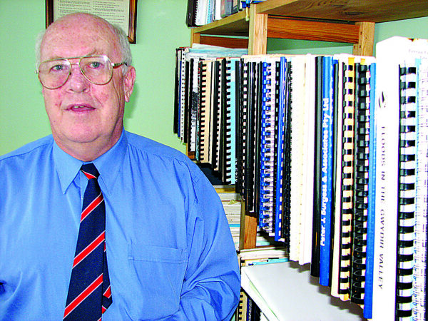
Image: Engineer Bill Paterson with his library of reports and information on levees in the Clarence.
As of February this year, just seven residents had taken up the offer for a council funding contribution towards the cost of raising their home.
Clarence Valley Council deputy general manager, Rob Donges, acknowledged that council hadn’t increased the height of the levee in response to the 2003 WBM report, but added that “the bucket of funding is not bottomless but the demands sometimes are”. Other pressures on council in regards to flood mitigation include a push by some Brushgrove residents for construction of a levee there to protect flood-prone homes.
Mr Donges said it was also important to note that the actual flood protection provided by the levee had not decreased.
“You’ve got to remember that these are statistical levels – it’s not like the actual levels of the levee have dropped. What it means is that overtopping may be more frequent than previously anticipated,” Mr Donges said.
Following the most recent flooding in the Clarence, WBM has again been recruited to carry out further investigations into the levee system. Council’s manager water cycle, Greg Mashiah, said while the report had not yet been finalised and tabled before Clarence Valley Council, it was anticipated to include recommendations for remedying a number of low spots in the wall that are below the 8.2 metre level at the Prince Street gauge, including at the end of Fry Street in Grafton. Residents had observed water topping the levee there during the recent event. There aren’t expected to be any recommendations for increases in the overall levee height.
It was somewhat startling talking to Mr Paterson to learn that at the time of his work on the Grafton and South Grafton levees in the 1980s, he was unaware that there were some low spots in the wall, such as at Fry Street. He said it wasn’t until the January 2011 floods that it became apparent to him that the Fry Street wall appeared to be a low point.
Mr Paterson said it was revealed to him around two years ago, during a conversation with the county engineer at the time of construction, Max Bown, that the Fry Street levee was actually lower by deliberate design. Mr Bown’s idea, according to Mr Paterson, was that if the river was to overtop it would be better to do so over a section of concrete wall, rather than earthen levee that was vulnerable to erosion. Mr Bown is now deceased.
Mr Paterson was unable to explain how such information failed to be passed on to him when he was carrying out his investigations and levee works in the 1980s, other than saying that engineers who had worked on the original levee had left council.
In finishing, I must apologise if this story has resulted in confusion. I have to admit, my head is spinning with the effort to try to understand a subject way beyond my technical knowledge. I suppose if we can take any message from the above, it’s that we’re possibly too comfortable with assuming that we won’t get a flood that tops the levee. We trust engineers to get it right, but they’re human and work with limited knowledge. They can’t possibly be expected to be able to predict with perfect accuracy how safe we are from flooding as a result of our levees. Another scenario I haven’t even gone near is the possibility of a levee collapse. And there is a vast array of other flood mitigation factors such as drainage, accuracy of warnings …
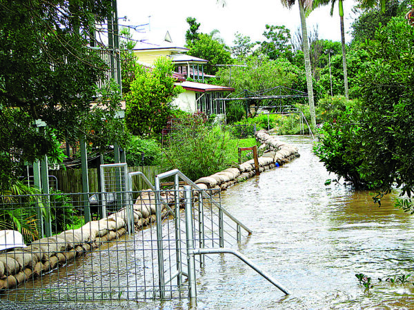
Image: Recent floodwaters threaten to inundate homes in Fry Street Grafton, which are particularly vulnerable because of a low spot in the levee.